Last Updated on September 4, 2025
The mountains of Western North Carolina are filled with stunning spots to stop and smell the rhododendron. And thanks to the Blue Ridge Parkway, many of them are very accessible. The gentle winding of the road and stunning vistas create memorable moments 469 miles long.
If you’re searching for something more challenging than a roadside overlook, we have just the thing: scenic hikes that lead to unforgettable views of their own. Here are just a few Blue Ridge Parkway hikes near Waynesville, NC, that offer unforgettable views.
Editor’s Note: Portions of the BRP are closed for repairs, but the stretch around Waynesville is open to visitors! Consult the BRP roadway closures list before planning your trip.
Looking Glass Rock
BRP Milepost: 417.0
Elevation: 4,492′
Length: 6.4 miles
Difficulty: Moderate to Strenuous
Description: Looking Glass Rock is one of the largest masses of granite in the eastern United States. It gets its name from the shimmer and sheen of its surface after a rain. A 6.4-mile hike takes you to the summit of the iconic pluton monolith, from which it’s popular to rock climb or enjoy the panoramic views of neighboring Transylvania County. Just a few miles from this overlook, locals and tourists alike enjoy the cool waters of Looking Glass Falls and Sliding Rock. From Looking Glass Rock, you’re also just a short drive to charming Brevard or the Cradle of Forestry, a 6,500-acre heritage site that marks where forest conservation was born in America.
Black Balsam Trail
BRP Milepost: 420.2
Elevation: 6,214′
Length: 1.4 miles, with options for longer loops
Difficulty: Moderate
Description: Black Balsam Trail scales Black Balsam Knob and is one of the greatest hikes along the Blue Ridge Parkway for its breathtaking and expansive views. Surrounded by wilderness, this tree-free “bald” mountain is an easy, family-friendly hike, ideal for picnicking or blueberry picking. Trek just half a mile out from milepost 420, and you’ll gain approximately 300 feet in elevation before breaking out of the tree cover at 6,000 feet. Reach the next bald, Tennant Mountain, by taking the Art Loeb Trail for another easy 1.5 miles.
Devil’s Courthouse
BRP Milepost: 422.4
Elevation: 5,720′
Length: 0.9 miles, round trip
Difficulty: Moderate
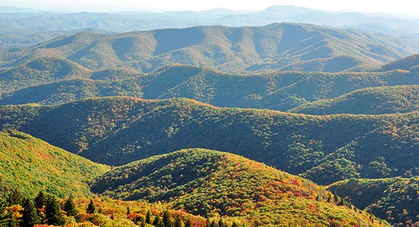
Description: This classic Parkway trail leads to the summit of the iconic, jagged, rocky peak with a sinister-looking profile. But there’s nothing sinister about the views, pictured above! The Courthouse opens to full panoramas perfect for a romantic picnic. Stay later in the afternoon for an amazing sunset. While the hike up can be challenging, it is mostly paved. Near the end, a spur trail connects to the Mountains-to-Sea Trail going to the left. Continue up the Devil’s Courthouse Trail to the right and follow it to the overlook. On a clear day, you’ll have views into Georgia, South Carolina, and Tennessee.
Richland Balsam
BRP Milepost: 431.0
Elevation: 6,401’
Length: 1.4 miles, loop
Difficulty: Moderate
Description: The Haywood-Jackson Overlook (milepost 431.0) is located along the ridgeline that forms the natural border between Haywood County on the far side and Jackson County on the near side. The self-guided trail from this overlook leads to the peak of Richland Balsam (6,401 feet). Just up the road, Richland Balsam Overlook (milepost 431.4, elevation 6,053 feet) is the highest point along the Parkway. This stopping point overlooks the southern Appalachian Mountains, with views of the Cowees, Nantahalas, and Plott Balsams. From the overlook, a trail walks you through the remains of a spruce-fir forest.
Soco Gap
BRP Milepost: 455.5
Elevation: 4,570’
Length: 0.6 miles, out and back
Difficulty: Moderate
Description: Located near the border of the Qualla Boundary, the Soco Gap overlook doesn’t offer the wide vistas of the other spots on this list. In fact, you may not see much other than a wall of rhododendrons and an access point for the Mountains-to-Sea Trail. But take the next turn onto Highway 19, and you’ll reach the Soco Falls Overlook in about a mile. Located on the Cherokee Reservation, the scenic Soco Falls Trail takes you from a viewing platform to a rare dual waterfall in just over half a mile. Enjoy the journey surrounded by woodlands. A steeper path leads to the base of the falls.
About the Blue Ridge Parkway
The 469-mile Blue Ridge Parkway was deliberately designed as a winding, scenic roadway. It provides the perfect venue for enjoying the Blue Ridge Mountains by bicycle, vehicle, or on foot. And with overlook stops every few miles, at most, you can stop as often as you wish to find the perfect view. It’s no wonder it’s called America’s Favorite Drive!
Enjoy great views from your Waynesville, NC home
In Western North Carolina, it’s easy to spend every day enjoying a brand new natural wonder in your back yard! High peaks surround the town of Waynesville, once billed as the Gateway to the Smokies and now the seat of Haywood County. Plus, Waynesville’s proximity to Asheville offers residents the best amenities of a larger city while still holding on to its small-town atmosphere. From outdoor adventures to cozy spots downtown, Waynesville welcomes people from many different backgrounds to visit and stay for life.
Does that sound like the perfect lifestyle for you? Find your dream home in Waynesville, NC now!